WebProNews

Tag: disasters

  • Twitter Expands Its Alert System

    Twitter Expands Its Alert System

    Twitter launched a new alert system for emergencies and other important information back in September. This morning, the company announced that it is expanding into the UK and Ireland.

    Nearly sixty accounts in the region have signed up to participate. These include 47 police forces in the UK, An Garda Síochána, the London Fire Brigade, the Mayor of London’s office, the Foreign Office, CEOP and the Environment Agency.

    The system enables such accounts to highlight information deemed to be critical to followers. Tweets are marked as alerts with an orange bell icon.

    Users who sign up for an accounts alerts will get notifications on their phones via SMS. iPhone and Android users will also get push notifications.

    “While participating organisations choose what information merits a Twitter Alerts designation, this feature is intended for crisis, disaster and emergency communications,” says Twitter’s Steve Summers.

    “We know from our users how important it is to be able to receive reliable information during times of crisis,” he adds. “With that in mind, last year we announced Lifeline (a feature that helps Japanese users find emergency accounts during crises), and since then, we’ve been working on a related feature for people around the world.”

    You can see all the Twitter accounts that are participating in the alerts system, by region, here.

    Image: Twitter

  • Google Maps Shows Before/After Moore, Oklahoma Tornado Imagery

    Google has a crisis response map for those affected by the giant tornado that ripped through Moore, Oklahoma. Included in that is imagery of the area from Google Maps.

    Google posted a before/after look at the area to its Google Maps Google+ account today:

    Google Maps

    We've published post-tornado imagery of Moore, OK on our Google Crisis Response Map ( http://google.org/crisismap/2013-oklahoma-tornado ). Here's a before (collected on 29th April by CNES 2013, Distribution Astrium Services/Spot Image) and after (collected on 22nd May by Digitalglobe) view showing Briarwood elementary school and the surrounding area – http://goo.gl/9pazZ. You can check/uncheck the boxes on the right of the map link to explore more information.

    In other Google Maps news, the company also revealed that it has been using its Trekker camera device to capture new imager from the Galapagos Islands. This imagery will be making its way to Google Maps later this year. You can see a preview here.

  • Tornado Death Toll Lowered: One Bright Spot In Oklahoma Storm Story

    The estimated death toll for the giant tornado that ripped through Moore, Oklahoma on Monday was drastically lowered today. While earlier reports had at least 51 people dead, including 20 children, the numbers have been revised to 24 confirmed dead, including 9 children.

    State officials announced this morning that fewer people had been killed than previously thought, with a spokesperson for the state medical examiner’s office saying in a news conference that some of the victims had been counted twice. While certainly no death toll could be considered a good thing, a reduced number of deaths is a bright spot in an otherwise ghastly ordeal.

    Emergency personnel continue to search for victims, including two dozen missing children from an elementary school that was destroyed.

    Google has launched a crisis map, providing resources for those affected by the storm.

    Photos and videos of the tornado and its destruction have flooded social media, giving the whole world a glimpse of the terror that ripped through the area. Here, you can see a video of the storm forming in Newcastle, OK. In this one, a woman finds her missing dog in the rubble while being interviewed by CBS.

    Image via reddit

  • You Have To See This Incredible Video Of The Oklahoma Tornado Forming

    There has been a lot of terrifying imagery of the tornado that terrorized the Oklahoma City area on Monday, but this incredible video shows the formation of the storm in Newcastle, OK.

    “The birth of the May 20, 2013 tornado at Newcastle, OK. It Moved from there to Moore where it turned into an F4. God be with its victims,” says Charles Cook in the YouTube video description.

    The video is currently the top entry in reddit’s r/video subreddit, under the heading: “Incredible video my Dad took of the May 20th tornado FORMING and destroying everything in its path near Newcastle, OK (0-F4 in seconds)”

    User solvitNOW, who submitted it, says, “He was out that way for work today and just happened to be in the right place at the right time. He was worried it was going to come back at him and was searching for a way to scoot out it’s way once he was able to gauge how insanely close it was to him. He hung in there, though. Unbelievable.”

    See some photos of the aftermath here.

  • Oklahoma Tornado Photos Are All Over Reddit

    A tornado, which reached an estimated width of two miles at one point, ripped through Oklahoma on Monday afternoon, leaving at least 51 people (including at least 20 children) dead, and an enormous path of destruction in its wake. On Tuesday morning, emergency workers continue to search for more victims. Update: apparently some of the victims were somehow counted twice, and the death toll has been reduced to 24 confirmed (9 children).

    According to a recent update from CNN, personnel have rescued over a hundred people from the rubble in metropolitan Oklahoma City. According to CBS News, there are still two dozen missing children from an elementary school that was destroyed.

    Photos and videos of the tornado and its destruction have flooded social media, giving the whole world a glimpse of the terror that ripped through the area.

    Reddit, in particular, has a plethora of photos (mostly hosted on Imgur) of the aftermath. Here are a few of the top photos from the r/pics subreddit with their reddit headlines:

    (image)

    Teachers Carrying Elementary Students out of School Leveled by Tornado in Moore, Oklahoma (soonerguy11)

    (image)

    A teacher finds one of his students among the rubble caused by the tornado in Moore, OK (robbinsc).

    (image)

    Picture taken in the tornado rubble in Moore, OK. (Fritoontheradio)

    (image)

    My brother’s friend after the tornado standing in front of his former house. (stratola)

    (image)

    Picture from my backyard of May 20th tornado that hit Oklahoma today. (BrokenRayn)

    More at reddit.com/r/pics, reddit.com/r/oklahoma, and no doubt countless other subreddits.

  • Second Sinkhole Appears in Tampa Bay Area

    Second Sinkhole Appears in Tampa Bay Area

    It appears that the Earth may be attempting to swallow Tampa Bay, Florida.

    Less than one week after a sinkhole reported to be 30 feet across pulled a man named Jeffrey Bush to his death, Reuters is reporting that a second sinkhole has appeared in the Tampa area. The new sinkhole opened up underneath a fence and no injuries have been reported. It is only around 5 feet deep and 12 feet wide, but it still has residents concerned for their lives and property.

    According to the Reuters report, Tampa officials have stated that this new sinkhole is unrelated to last week’s deadly one.

    The sinkhole that caused the death last week opened up underneath Bush’s bedroom, swallowing Bush and his bedroom furniture. That hole was 60 feet deep and authorities have stated they do not expect to be able to recover Bush’s body. The house in which the sinkhole appeared has been demolished, and residents near the house have been evacuated as a precaution.

    The Florida Department of Environmental Protection states that limestone in the state is porous and vulnerable to acidic water. As the water dissolves the limestone, caverns form, which can then collapse to form a sinkhole.

  • Donate to Hurricane Sandy Relief While Using iTunes

    Apple and the American Red Cross have partnered to help superstorm Sandy survivors by adding a donation page to iTunes this morning.

    From the iTunes homepage, you can access the donation page via a new button just under the new music box.

    The donation page allows you give in six different denominations – $5, $10, $25, $50, $100, and $200. In order to donate, you must be logged in to your Apple account and the donation will be charged to whatever card you’ve linked to it. As always, 100% of your donation goes directly to the American Red Cross.

    It’s important to note that you can’t use iTunes Store credit to make your donation.

    Of course, this is not the first time that Apple has allowed iTunes to be a hub for donations following a natural disaster – but it’s nice to know that there’s another method out there to help those in need. You can access the page directly here.

  • “We Are Ok” Is Facebook’s Top Term Following Hurricane Sandy

    Yesterday, as the east coast was preparing for Hurricane Sandy’s landfall, FEMA sent out a few tweets suggesting that those affected by the storm refrain from making voice calls on their cellphones. Instead, FEMA suggested that people text or better yet post Facebook updates and tweets in order to let their loved ones know that they are ok. This way, less bandwidth would be tied up and everyone would have a better chance for their communications to get through.

    Hurricane Sandy slammed into the coast Monday evening, and left a trail of destruction behind her. Areas in states like New York, New Jersey, and Pennsylvania are still dealing with massive flooding, and residents are still coping with the inability to travel from place to place.

    But according to Facebook, people seem to have taken FEMA’s advice. Facebook’s media page recently posted the 10 most-shared terms by Facebook users as of this morning, and “We are ok” tops the list.

    Here’s the complete top 10:

    1. we are ok
    2. power – lost power, have power, no power
    3. damage
    4. hope everyone is ok
    5. trees
    6. made it
    7. safe
    8. thankful
    9. fine
    10. affected

    As you can see, five of the top ten terms involve people letting other know they are alright. Social media has changed a lot of things in our world over the last decade, and this is just another example of that. In times of disaster, services like Facebook and Twitter can be a lifeline, and other services like Tumblr and Instagram can give us a window into the action as it happens.

    [Lead Image Courtesy Doxella, Flickr]

  • Asteroid DA14 Misses Earth In Animated, Data-Backed Video

    For those of you still fretting that Earth will get smacked with a 40 meter-wide asteroid next year even though reliable experts have said that these fears are overstated, here’s a computer-animated rendering of how exactly Earth won’t be in any danger.

    Well, at least as far as asteroid 2012 DA 14 goes.

    The video, which was uploaded by YouTube user CelestiaDev, is daringly accurate with its measured time estimates of the asteroid’s trajectory. Several different vantages are presented that all show the asteroid, while at times looking to collide with earth, completely missing our planet. What’s more is that you’ll see how it does in fact get closer to Earth than many of our own satellites hanging around in orbit.

    The video isn’t just compiled by somebody’s inventive imagination, either: the depiction was constructed using the calculations of Jet Propulsion Laboratory’s HORIZONS solar system data and ephemeris computation service.

    Honestly, though, I’m really not sure if this animation will allay any of the concerns people have about our planet getting hit with an asteroid or if it will actually make them worse because, as the video shows, that asteroid looks to pass frighteningly close to Earth.

    Still. It’s going to miss us by over 13,000 miles. Gravity is the weakest of the four fundamental forces in nature. We break this force every single day of our lives and we are not 25-mile-wide space rocks. If we can have our way with Earth’s gravitational force anytime we like, you really think our planet’s gravitational pull is gonna be enough to suck in asteroid DA 14?

    It’s seriously not going to happen, people.

  • Google, World Bank To Improve Disaster Preparedness In Developing Countries

    Within a generation, we will no longer leave the house. We won’t need to. Mobility will become obsolete. Similar to our regard to the appendix and nipples on males, feet will become lumpy appendages whose purpose we no longer remember. We will not be mobile but, rather, we shall be rollerblobby Twinkie sapiens who can travel every inch of Earth and beyond without so much as lifting our thumbs thanks to the efforts of Google to literally map everything.

    But that’s neither here nor there. For now, at least.

    For now, Google is still doing some pretty awesome stuff with their Maps technology in order to improve the quality of life for many, many people. Their Flu Trends is helping hospitals stay better prepared for influenza outbreaks and today Google announced that they are partnering with World Bank to collaborate on ways to make Google Maps an effective tool for developing countries to prepare for disasters. The announcement from Google’s Lat Long blog offers up the goods:

    Under this agreement, the World Bank will act as a conduit to make Google Map Maker source data more widely and easily available to government organizations in the event of major disasters, and also for improved planning, management, and monitoring of public services provision.

    The free, web-based mapping tool called Google Map Maker enables citizens to directly participate in the creation of maps by contributing their local knowledge. Once approved, those additions are then reflected on Google Maps and Google Earth for others around the world to see.

    The Google Map Maker data includes detailed maps of more than 150 countries and regions, and identifies locations like schools, hospitals, roads, settlements and water points that are critical for relief workers to know about in times of crisis. The data will also be useful for planning purposes, as governments and their development partners can use the information to monitor public services, infrastructure and development projects; make them more transparent for NGOs, researchers, and individual citizens; and more effectively identify areas that might be in need of assistance before a disaster strikes.

    The Global Facility for Disaster Reduction and Recovery will helm the project, Google says, and will build upon prior mapping efforts to “create comprehensive maps of schools, hospitals, and other social infrastructure” in new, developing countries via Map Maker technology.

  • See The Japan Earthquake / Tsunami Damage Through Before & After Street View

    Back in March, a devastating earthquake and subsequent tsunami caused massive damage to a large part of eastern Japan. A few months later, Google announced that they would be driving their Street View cars around, taking photos of the damage. They said that this would serve as a digital archive of the power of mother nature for future generations.

    Today, they’ve announced that the project has come to fruition. 44,000 kilometers worth of driving has yielded some unbelievable before and after photos that are now available for everyone to see using Street View.

    In the bottom left corner of each image you’ll also see a month and year that tells you when a particular photograph was taken. When looking at images of the magnificent cities side-by-side with images of the ruins left in their place, this additional context demonstrates how truly life-changing this tragedy has been for those who live there and witnessed the destruction of their homes, neighborhoods and even entire districts.

    This timestamp feature has been the most requested Street View feature for the last few years, and it is now available on Street View imagery worldwide. Professionals such as historians, architects, city planners and tourism boards—as well as regular users including travelers and home-buyers—can now get a sense of how fresh the online photos are for a locations that interests them

    You can access the new Street View photos by simply going to Google Maps and entering Street view in the specific areas, but it’s better if you visit the Build The Memory site, which is devoted to the before and after shots.

    It might be a little tough to find perfect before and after shots, but if you search up Japan’s Northeast coast, it won’t take you too long. Once you zoom in on a particular area, you can hit the “before” or “after” buttons at the top and see a photo of the same location, either pre or post tsunami.

    Doing so will give you amazing contrasts like these from Onagawa, Oshika Distrcit, Miyagi Prefecture:

    Before:

    After:

    Before:

    After:

    As you can see, the devastation is immense. At least this sort of thing can provide context for people who were too young to remember the disasters or perhaps hadn’t even been born yet. Another interesting visualization of the Japan disasters was released by Twitter back in June. It shows the volume of tweets being sent during the earthquake and the chaotic period afterward.

  • Tropical Storm Katia Tracks in Irene’s Footsteps, Finds Disaster Fatigue on Twitter

    Hurricane season is far from over, but it seems as though people are already feeling the effects – I’m talking about disaster fatigue.

    A complicated concept, it involves any of the following symptoms: General apathy, specific apathy toward any discussion of said event, hopelessness, anger over unchangeable circumstances, tendency to expect the worst, humor in response to frightening possibilities and so on an so forth.

    On the heels of Hurricane Irene, a weather event that not only battered the east coast of the United States but battered people’s psyche with social media overload, we have Tropical Storm Katia. Recently updated from a Tropical Depression to a Tropical Storm, Katia is currently moving across the Atlantic.

    And the internet is flustered.

    Right now, Katia is moving Northwest at about 17 MPH, around 500 miles southwest of the Cape Verde Islands. Projections say that the storm might intensify into a Category 3 Hurricane or stronger by the end of the week. Some models indicate that the storm might turn north before hitting the east coast of the U.S., but other suggest that it could take a path similar to Irene.

    Twitter is talking about Katia, and the responses range from frustration to disbelief to apathy and back around to borderline panic. Here’s what I mean by disaster fatigue –

    Here we go again…. Tropical Storm Katia 12 minutes ago via Twitter for iPhone · powered by @socialditto

    Worlds over !! QT @Legacy_450: First a 5.9 earthquake..then Irene..now a tropical storm Katia 15 minutes ago via twicca · powered by @socialditto

    Tropical Storm Katia sounds hot 2 minutes ago via web · powered by @socialditto

    Tropical Storm Katia. GO ahead turn into a hurricane. Hit the East Coast. Irene couldn’t take us. Neither will you #winning @JennyHall12 5 minutes ago via web · powered by @socialditto

    Tropical Storm Katia – The Russian prostitute edition. 15 minutes ago via web · powered by @socialditto

    Hurricane Irene slammed the east coast over the weekend leaving over 30 people dead and over 6 million without power. Flooding has been a huge problem in many different states, but some questioned whether or not the event was over-hyped from the start. Some said that the hurricane didn’t hit with the ferocity that was predicted while others quoted the above stats in an effort to relay the seriousness of the storm.

    Remember some of the thoughts about Irene?

    If Katia intensifies and moves toward the east coast, can you imagine how it will explode across social media?

    Irene did a lot of damage to the east coast and people are still reeling. Katia is the 11th named storm of the season. Historically, the 11th named storm of the season doesn’t come until late November. Let’s just hope that Katia veers north and leaves us the hell alone.

    [Image Courtesy Weather Underground]

  • Mississippi Flood Photos from Google Maps Satellite Imagery

    Google has put together a whole bunch of data and imagery from the Mississippi floods on Google Maps.

    On Google’s Lat Long Blog, Pete Giencke of the Google Crisis Response Team writes:

    Emerging as one of the worst flooding events along the U.S. waterway in the past century, the Mississippi River floods of April and May 2011 have caused widespread destruction along the 2,300 mile river system. Historically high water levels from heavy rains and springtime snowmelt have provided no shortage of dramatic scenes — levees breached, downtown areas completely submerged, spillways opened, and more.

    The Google Crisis Response team has assembled a collection of flood data including satellite imagery for impacted cities along the river from GeoEye, flood extent and crest data forecasts from the US Army Corps of Engineers (kml) and NOAA’s National Weather Service (kml), and shelter locations from the American Red Cross (kml).

    The image at the top is Morganza, Louisiana on May 15. The following image is from Cairo, Illinois on May 8.

    Mississippi flood imagery

    Google Crisis Response is a project of Google.org, the company’s philanthropic arm. Its stated goal is to make critical info more accessible around natural disasters and humanitarian crises. Just this year it has provided data and resources for the earthquake/tsunami in Japan, the Christchurch earthquake, the Brazil floods and landslides, and Australian floods.

    Last year, it provided resources for the Pakistan floods, gulf oil spill, Qinghai earthquake, Chile earthquake, and Haiti earthquake. In 2009 it provided resources for Typhoon Morakot, the Lockheed Wildfire in Santa Cruz, the L’Aquila Earthquake, and Red River Floods.

    To see all available data for the Mississippi floods, simply search for “Mississippi flooding” on Google Maps. The data is also accessible in Google Earth via the “places” layer.

  • Social Media Disasters: The Do’s and the Don’ts

    There are numerous examples in which companies really messed up on social media. For instance, remember Apple’s Antennagate incident or BP’s response to the Gulf oil spill? Both of these incidents resulted in a negative outcry toward both companies on social media channels.

    Can you think of other examples when companies poorly handled their social campaigns? Let us know.

    However, the difference between Apple and BP’s incidents is that Apple has a strong brand presence and BP does not. Apple was able to come back and reclaim its consumers, and although BP made some modifications, its efforts did not have the same affect as Apple’s did.

    Social media can be tricky anytime, but especially during a crisis. According to Rob LaGesse, the Director of Media Marketing at Rackspace, “Social media can get you fired, but social media can also keep you gainfully employed.”

    LaGesse is familiar with these disaster situations because Rackspace itself has experienced them. Back in 2009, the company had a data center power outage, which could have potentially been very detrimental to its reputation. However, the CEO appeared on YouTube to explain what had happened and how it would be resolved. Rackspace continued to update its customers through social media until the outage was completely restored.

    As a result, the company was able to take a disaster situation and use it to build a stronger connection to its customers. Looking at experiences such as this, Rackspace developed a social media plan based simply on the idea of being helpful.

    It’s no secret that consumers use social media to complain about brands and companies. But, LaGesse said that it is the responsibility of brands and companies to help consumers, even in spite of negativity.

    “A lot of people think they can control their brand on social media, and you really can’t. All you can do is do the right thing by your customers,” he pointed out.

    He explained that customers have to come first, and if they do, the branding aspect of a business will take care of itself. On top of this, he added that companies need to be honest, open, and communicate through a real human being.

    By applying these steps to social media, LaGesse believes that you can not only have an effective social media campaign, but that you will also be able to build a support group that takes up for your brand in disaster situations.

  • Google Steps In After San Bruno Explosion

    Google Steps In After San Bruno Explosion

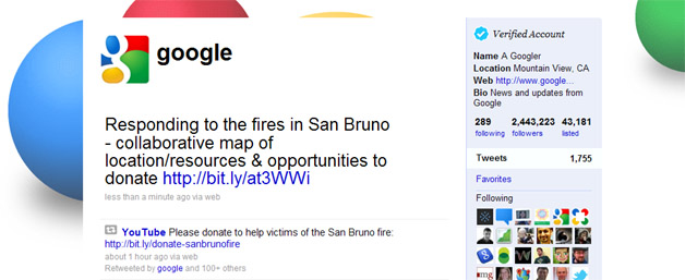
    Google often steps in when disaster strikes, helping people in Chile, China, Haiti, and Pakistan (among many other places) to date.  And now that fire’s claimed several lives and many homes in San Bruno, California, the company’s trying to render assistance again.

    A quick note in case anyone with friends or family members at Google is reading: a post on the Official Google Blog explained that "no Google employee was hurt" even though "[t]his disaster strikes close to home; our YouTube offices are about two miles away from the main gas explosion."

    Otherwise, one significant way in which Google’s helping people who have been affected is with a substantial donation.  The company gave an "initial amount" of $50,000 to the American Red Cross Bay Area Chapter, since it’s closely involved with relief efforts.

    Also, Laszlo Bock, Vice President of People Operations, wrote, "We’re directing Googlers to the local blood drives today and will be hosting blood drives in our San Bruno, Mountain View and San Francisco offices early next week."

    Then there’s the simple matter of Google doing what it can to get other organizations and individuals involved.  Between the corporate blog post and a couple of tweets, it’s possible that Google will bring the situation to the attention to several million people.

  • BusinessWire Offers Free Haiti-Related Press Release Distribution

    Popular press release distribution site BusinessWire, which is owned by Berkshire Hathaway, is offering its services for free to companies and organizations who are contributing to the aid of victims of the earthquake in Haiti. Such companies can push out free news releases with offers pertaining to supporting services, information, operations, and events directly related to rescue and recovery efforts.

    BusinessWire asks member companies to submit press releases as they normally do via the site’s online order interface, and to follow up with their local newsrooms. Other organizations are given the following phone number to call for further details: 888.381.9473

    BusinessWire has consolidated all of its Haiti Earthquake-related press releases into one spot, so the information is easily accessible. That can be found here.

    BusinessWire Haiti News Archive

    This is just one example of many showing how the web is contributing directly to relief efforts for victims of the disaster. There are a lot of companies and organizations offering varying services, and Business Wire’s own offering provides for a good way to spread the news as well as get a look at different ways one can help.

    Participating companies so far include Dollar General, Kohl’s, Walgreens, Discover, GE, Sprint, Comcast, T-Mobile, Target, and many more.

  • Google Launches Relief Site To Help Haiti

    Google Launches Relief Site To Help Haiti

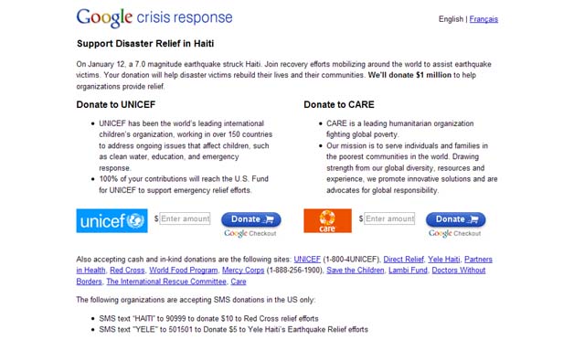
    Survivors of the earthquake in Haiti are going to receive help from Google in a big way.  On a new Support Disaster Relief site, Google’s released satellite imagery of the destruction to spread awareness, created a list of relevant charities to encourage donations, and promised to contribute $1 million of its own money, as well.

    Let’s discuss the awareness efforts first.  The fresh satellite imagery was obtained with the help of GeoEye, and the pre- and post-earthquake shots are rather startling to see.  Google also noted that more information is available from local media sites and the U.S. State Department, plus it’s published the contact numbers of seven different Haitian hospitals.

    As for the fundraising side of things, the search giant had plenty more to say.  Google named UNICEF, Direct Relief, Yele Haiti, Partners in Health, the Red Cross, the World Food Program, Mercy Corps, Save the Children, the Lambi Fund, Doctors Without Borders, the International Rescue Committee, and Care as organizations that are accepting donations, and pointed out that it’s possible to give money with text messages.

    Google even created two buttons to allow people to donate to UNICEF and Care directly from its Support Disaster Relief in Haiti site.

    Altogether, this represents a quick, thoughtful, and thorough response to a terrible event.

    Related Articles:

    > Gmail Switches To Default Https Encryption Following Attack

    > Google May Quit China

    > Google Shows Flu Trends For 121 Cities In The U.S.