WebProNews

Tag: bing maps

  • Bing Maps Getting Deep Into Route Planning

    Bing has implemented a whole new routing engine on Bing Maps with a new route calculation algorithm.

    The new algorithm changes how driving directions queries are computed.

    Algorithms behind routes on search engines’ maps probably aren’t something that most of us give a whole lot of that, but Bing clearly wants us to know how proud they are of this, having devoted not only a blog post about it, but an entire research paper.

    “It started when I took over as PM of backend services for Bing Maps,” says Chris Pendleton. “The Microsoft Research team presented this crazy new idea to replace our modified Dijkstra’s algorithm with the blandly named ‘Customizable Route Planning’ algo. We’ve been using our own modified Dijkstra for years, it’s done a great job and it’s flexible – so, why would we change that? Once we saw the calculation numbers it was a no brainer to begin implementation immediately. For any of our route calculations we’re now processing requests twice as fast as we ever have. Oh, snaps! Now, if only CRP could double the speed limit. Future enhancement!”

    The “special sauce” of the routing engine, Pendleton says, is a feature in the API for altenate routes. Applications can request up to 3 separate routes in one request, which can be displayed on the map. Here’s what Pendleton has to say about the basic algorithm:

    Our metric-independent preprocessing stage partitions the graph into connected cells with at most U (an input parameter) vertices each, with as few boundary arcs (arcs with endpoints in di erent cells) as possible. The metric customization stage builds a graph H containing all boundary vertices (those with at least one neighbor in another cell) and boundary arcs of G. It also contains a clique for each cell C: for every pair (v;w) of boundary vertices in C, we create an arc (v;w) whose cost is the same as the shortest path (restricted to C) between v and w (or in nite if w is not reachable from v). We do so by running Dijkstra from each boundary vertex. Note that H is an overlay [24]: the distance between any two vertices in H is the same as in G. Finally, to perform a query between s and t, we run a bidirectional version of Dijkstra’s algorithm on the graph consisting of the union of H, Cs, and Ct. (Here Cv denotes the subgraph of G induced by the vertices in the cell containing v.) As already mentioned, this is the basic strategy of separator-based methods. In particular, HiTi [19] uses edge-based separators and cliques to represent each cell. Unfortunately, HiTi has not been tested on large road networks; experiments were limited to small grids, and the original proof of concept does not appear to have been optimized using modern algorithm engineering techniques. Our rst improvement over HiTi and similar algorithms is to use PUNCH [5] to partition the graph. Recently developed to deal with road networks, it routinely nds solutions with half as many boundary edges (or fewer), compared to the general-purpose partitioners (such as METIS [20]) commonly used by previous algorithms. Better partitions reduce customization time and space, leading to faster queries. For our experiments, we used relatively long runs of PUNCH, taking about an hour. Our results would not change much if we used the basic version of PUNCH, which is only about 5% worse but runs in mere minutes. We use parallelism: queries run forward and reverse searches on two CPU cores, and customization uses all four (each cell is processed independently).

    The research paper can be found here, in PDF form.

  • Bing Adds Mall Maps to Mobile Search

    Bing Adds Mall Maps to Mobile Search

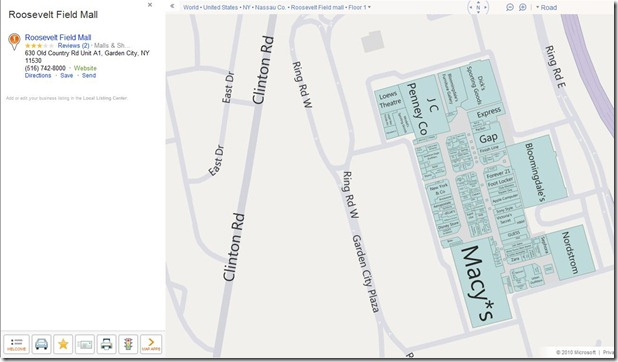
    Bing has added mall maps and map search to Bing for Mobile. Microsoft’s search engine currently has over 400 shopping malls available in map form.

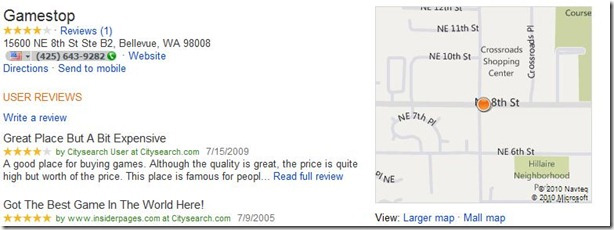
    “Venue maps are a great way to save time and frustration when planning your next summer vacation or that last minute shopping trip – getting you in and out the door faster. Additionally, we now also provide the capability to search on the map,” says the Bing Maps team. “We’ve made locating mall maps an easy task from your desktop or m.bing.com. Just search for the mall name on Bing or Bing Maps, then click on the Mall Map link in the search results contact card.”

    “You can also view different levels of a specific venue by clicking the ‘Level’ button at the top of the screen and then selecting the correct level from the provided list,” the team says.

    Bing Mall Maps for Mobile

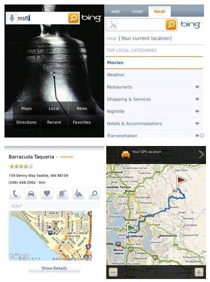
    Bing has also added the ability to search from Bing Maps itself. Search results utilize the split view syncing a list and map view in a single view.

    “Pan the map and hit refresh and the results in the list will change based on the position of the map,” the Bing team says. “The map highlights the business locations as you scroll through the list making it easy to see where all the options are located.  Clicking on a list item such as a business listing will move the map to focus on that business.  Similarly, clicking on a point of interest on the map updates the list.”

    The features are supported on iPhone, Android and RIM devices. They can be accessed from m.bing.com.

  • Bing Rolls Out New Maps Interface

    After months of testing, Bing has now made available its new interface for Bing Maps. Changes include adjustments to the task and navigation controls. Bing says it’s now easier to find the most common actions to complete your tasks.

    “We’ve consolidated actions that were previously scattered throughout the page, and concentrated them along the top, where you expect to find them,” explains Senior Program Manager Dan Polivy. “We’ve included text labels for most of the buttons. And, most importantly, we’ve focused on making the controls accessible while still allowing the map to be the focus of the page.”

    Here’s a look at the before and after (respectively):

    Bing Maps UI - Before

    Bing Maps UI - After

    “These improvements are being rolled out to all of our international sites with appropriate market-specific functionality,” notes Polivy. “For example, Bing Maps users in the UK will still have access to the London Street Map and Ordnance Survey styles, along with our standard Road map, via the vector style drop-down. The public transport overlay, showing tube, DLR, and tram networks, is also readily available from the navigation bar when the map is centered over the greater London area.”

    Bing has also added accessibility of its Bird’s eye 45-degree and high resolution Aerial imagery views from the top of the navigation bar. With that, Bing has made it easier to switch between views in general with a single click.

    Bing Maps interface updates and geolocation support 
    http://binged.it/pJZmFC 16 hours ago via CoTweet · powered by @socialditto

    Finally, there’s a new “locate me” button, which will center the map around your location, if you’re using a browser that supports the W3C Geolocation API.

  • Bing Maps Streetside View Comes with Some New Views

    Bing has launched some changes to its Bing Maps street imagery with Streetside View. “With these updates you can quickly and seamlessly pan the neighborhood, check out a business down the block, or make a ‘u-turn’ to cross the street, among other things,” a Bing representative tells WebProNews “So whether you need to see a straight, flat area in New York, or a steep, winding road in San Francisco, your online mapping experience is more immersive than ever.”

    “These changes represent a significant enhancement for desktop browsers, enabling you to quickly pan up and down the street to see the neighborhood and find businesses,” explains Bing’s Chris Pendleton. “We are doing this by providing street level panoramas so you can take a virtual walk through the streets with a view of locations and landmarks. As you slide the street level imagery sideways, the view of the sidewalk is seamlessly constructed including an overlay of business listings, street names and store fronts.”

    “In the past you explored Streetside imagery by navigating between ‘bubbles,’ or discrete 360 degree views, and moving down the street was accomplished by jumping from bubble to bubble. This works, but makes it difficult for you to get a sense for a larger area like a city block. Moreover, it’s hard to pick out storefronts farther away since you really only see the ones directly perpendicular to your viewpoint with great clarity,” says Pendleton. “This new style, on the other hand, keeps the immersive experience but adds smooth left/right panning navigation that makes it easy to find what’s nearby more quickly. The street flows by as a series of smooth ground-level photographs so now you simply pan up and down the street to see the neighborhood and find what you are looking for.”

    Get up close and personal with that gyro shop – new BIng Maps view: http://binged.it/lIrJDq 4 hours ago via Seesmic Web · powered by @socialditto

    The street map remains above the imagery, so if you get lost in your streetside journey, you shouldn’t have much trouble figuring out where you are. Below the imagery, you will also see an overlay of the names of businesses and bus stops.

  • Nokia to Replace Bing Maps Infrastructure?

    As you may know, Microsoft and Nokia signed a deal last month, aimed at creating a “third horse” in the smartphone race (alongside Apple’s iOS and Google’s Android platforms [kind of insulting to RIM, no?]). As part of the deal, the two companies indicated that Nokia Maps would become a core part of Microsoft’s mapping services, and would be integrated with Bing.

    “Maps would be integrated with Microsoft’s Bing search engine and adCenter advertising platform to form a unique local search and advertising experience,” the press release said.

    That integration might be much bigger than anyone realized, however.

    Greg Sterling at Search Engine Land says he had lunch with a “person with close connections to Nokia,” who told him that Nokia Maps would “effectively replace almost everything that Microsoft had developed over the past several years in terms of the Bing Maps infrastructure”. Sterling writes:

    I said I couldn’t believe Microsoft would agree to swap in Navteq for the guts of its own system. Yet my lunch guest argued that Microsoft’s role would mostly center on the Bing Maps UI — ironically not unlike Yahoo’s relationship to Microsoft search results — everything else would be powered by Nokia.

    And there was another very interesting remark. He asserted that Google’s unwillingness to agree to a co-mingling of Google Maps and Nokia Maps or substitution of Nokia Maps on the back end was one of the sticking points that prevented Nokia and Google from coming to terms.

    Navteq is a GIS data provider, owned by Nokia. It counts plenty of big brands (including Microsoft) among its customers.

    Based on the circumstances, we can only file this one under rumors at this point, but as Sterling points out, Microsoft and Nokia were indeed quite vague on the details about any Map integration resulting from the partnership.

    At this point, it’s unclear what would become of much of the progress Bing Maps has made on its own, and its own integrations – Bing Maps apps, for example. We’ve reached out to the Bing Team for comment, and will follow-up with any additional details.

    Update: Bing simply gave us the following canned response: “Bing Maps has utilized Nokia content for road data, geo-coding and routing services for several years, through Nokia’s Navteq vector data business, relying on the quality of its data for core location services. The Nokia/MS partnership will enable deeper collaboration and an improved experience for our customers in the future.”

  • Bing Adds Shopping Mall Maps to Local Results

    Bing is now including Bing shopping mall directory maps in Bing Maps. 

    "Have you ever driven to a mall, parked at one of the big department stores, then discovered the store you needed to go to was on the other side of the mall? What about experiencing the frustration of not knowing where in the mall is the store you need and the mall directory is nowhere in sight? And with malls being extra busy now that we’re in holiday season, we’ll take anything we can get to help us get in, get out, and avoid the crowds," said Bing Maps Product Manager Brian Hendricks. 

    Bing Mall Maps

    "You can use these mall maps to figure out where the right place to park is and map out your mall excursion so you don’t spend precious time walking around," says Hendricks.

    Bing Mall Maps

    Users can find the mall maps by clicking "Mall Map" within Bing Local results. 

    So far, Bing only has maps for malls in Seattle, Boston, and New York  metro areas, but they will continue add more regularly. 

  • Microsoft Names Principal Architect Of Bing Mobile

    A man who fostered a great reputation in the geospatial community by founding OpenStreetMap, "a free editable map of the whole world," has started working for Microsoft.  The company announced today that Steve Coast will assume the impressive title "Principal Architect of Bing Mobile."

    We should note right here: this development doesn’t mean Coast is turning his back on OpenStreetMap or the geo community in general.  As part of the deal, Coast apparently made sure that Microsoft will be allowing access to its global orthorectified aerial imagery.

    Also, a post on the Bing Maps Blog explained, "As a Principal Architect for Bing Mobile, Steve will help develop better mapping experiences for our customers and partners, and lead efforts to engage with OpenStreetMap and other open source and open data projects."

    open maps images

    So it looks like this move is going to benefit Bing, Bing’s users, and people who prefer to steer clear of legal and technical restrictions when it comes to mapping.  Along with Coast himself, presumably.

    Coast wrote on his blog today, "[I’m] super excited to tell you that I’ve accepted a position as Principal Architect at Bing Mobile and am moving to the Seattle, Washington area to work on maptastic things!  Yay!"

  • Bing for Mobile for BlackBerry Gets Update

    Microsoft announced an update for its Bing for Mobile BlackBerry app. The app can now access Bing Maps by pressing the Bing Maps icon from a user’s BlackBerry device. 
    In addition to this, the home screen has been updated, and a launcher has been added, so local, maps, directions and news can all be accessed faster. 


    Bing for Mobile for BlackBerry
    The app supports the following devices:


    BlackBerry Curve 8500
    BlackBerry Curve 2 8520/8530
    BlackBerry Bold 9000
    BlackBerry Tour 9600
    BlackBerry Bold 9650 (Essex)
    BlackBerry Bold 9700 (Bold2)
    BlackBerry Pearl Flip 8200
    BlackBerry Storm 9530
    BlackBerry Storm 9550 (Storm2)


    The app can be downloaded from m.bing.com from the device. Verizon users will be notified with an update. Microsoft has a video about the app available here.
     
  • Lots Happening with Bing Maps Today

    "Bing Maps just got more useful for developers, bus and train commuters and education advocates everywhere," a representative for Bing tells WebProNews. She is referring to a series of announcements Microsoft made today regarding Bing Maps. 

    The company released two new Bing mapping apps, made additions to the Bing Transit Map, and released the final Windows Phone 7 SDK which features Bing and Microsoft Advertising.

    Education

    Bing’s  two new mapping apps are part of the Our School Needs campaign, which is focused on supporting schools across the U.S. through funding and volunteer efforts.

    The first app is for DonorsChoose.org. It helps people find and support classroom projects in their community. "The app identifies and highlights school projects that are looking for funding," the rep explains.  "People can explore and donate by location, subject area, funding required and other criteria. Schools, school districts and donors can also embed a DonorsChoose Bing Map in their own website making it easy to spread the word."

    The second app is simply  Bing Education. It’s designed to help people find opportunities to help students in their neighborhoods. "In addition to features found in the DonorsChoose.org app this app displays local school information and donation, mentor, and volunteer opportunities in the area," she says. "The app features opportunities from Mentor Pro, Great Schools, and DonorsChoose.org."

    Transit

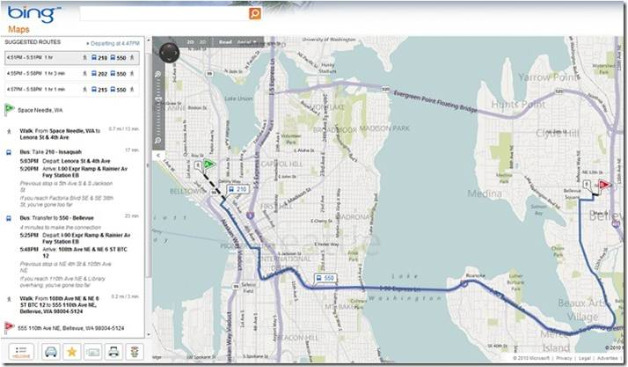
    As far as additions to Bing Transit Map, bus and rail transit directions are now alongside driving and walking directions. The transit directions will first be available in major U.S. metropolitan areas such as Boston, Chicago and Los Angeles, and will roll out to additional cities in the future. "The information in the Bing Transit map is provided by various transportation agencies in major metropolitan regions," says the rep. "Please note, Bing Transit only works on AJAX supported sites."

    Bing Maps Transit

    More details and a complete list of available cities can be found here.

    Windows Phone 7 SDK

    Bing Maps, which is of course the default mapping service on Windows Phone 7, is now fully integrated into the Windows Phone 7 Developer Toolkit with the Bing Maps Control SDK. Bing says this makes it simpler for developers to build Bing mobile mapping apps. "Like all other Bing Maps APIs, the Windows Phone 7 control is free for use in consumer-facing mobile applications," the rep says. More info on Windows Phone Developer tools are here. More on the Advertising SDK specifically here.

  • Bing Maps Integration Comes to Hotmail

    Bing Maps Integration Comes to Hotmail

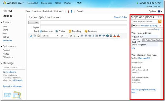
    Microsoft has launched some new Bing Maps integration with Hotmail. When Hotmail users create a new email message, they can insert Bing Maps data.

    When a user selects "Maps and Places", a task pane opens, which lets you add new locations or interact with previously defined locations. It will default to the address you have in your Windows live profile. If you add a new place, you can store it in a Bing Maps collection and pick it from a list later.

    "Once you made a quick pick from the list or geocoded a new address you can optionally edit the details and then insert it into your email," says Bing’s Johannes Kebeck. "I think that’s a great idea. If only I could have that in Outlook too."

    Hotmail Gets Bing Maps integration

    In other Bing Maps news, Microsoft Visual Studio LightSwitch has just been released as public beta, and the company shows how it uses this with Bing Maps here. Microsoft says Visual Studio LightSwitch is "the simplest way to build business applications for the desktop, web and cloud."

  • Bing Maps Gets Interface Enhancements

    Microsoft has launched an update to the Bing Maps interface today aimed at improving readability and aesthetics.

    The new interface uses cool colors, which Bing says creates a more visually appealing backdrop, helping content "pop" on the map, and provides clear differentiation for pushpins, labels, and traffic overlays.

    There are new labels with larger fonts for major streets. This eliminates the need for bolding, and less attractive glows while allowing users to quickly find locations in a relevant format, Bing says.

    Bing Maps Interface Gets Redesign

    The new interface also comes with improved international coverage. There is improved road and street data across Central and Eastern Europe, the Middle East, Oceania, and Asia.

    Finally, Bing Maps has launched Dynamic Labels in beta, which allow users to quickly zoom to a region or location on the map with just a few clicks, making it easier to identify and explore areas or neighborhoods of a city. These labels can be turned on from the map style selector on bing.com/maps/explore.

    As reported earlier, Bing now offers an app for OpenStreetMap, a Wikipedia-style community-driven mapping interface.

  • Bing Maps Gets OpenStreetMap App

    Bing Maps Gets OpenStreetMap App

    Microsoft has launched a new Bing Maps app for OpenStreetMap. The app adds a layer on Bing Maps as a new style option.

    "OpenStreetMap follows a similar concept as Wikipedia, but for maps and other geographic facts (despite its name, it’s by no means only limited to streets and roads)," explains Bing’s Chris Pendleton. "People, like you and me, gather location data across the globe from a variety of sources such as recordings from GPS devices, from free satellite imagery or simply from knowing an area very well, for example because they live there. This information then gets uploaded to OpenStreetMap’s central database from where it can be further modified, corrected and enriched by anyone who notices missing facts or errors about the area."

    Bing Maps Adds OpenStreetMap

    "Users can still perform searches atop of the OSM map layer," adds Pendleton. "Once the OSM Maps are rendered, users will find the OSM map option listed in the map types so if you switch to Bird’s Eye or some other native Bing map types, you can easily return to the OSM map style. Of note, we are using the Mapnik map style from OSM (one of the many map styles available to open source users) to create our OSM map type. People love the details you see?"

    It should be interesting to see how the OpenStreetMap grows from community participation, and how it looks compared to other map offerings.

    Bing is doing some interesting things with maps through its Maps Apps. They’ve recently launched apps for Facebook, Foursquare, health, and the Tour De France, not to mention Mars imagery.

  • “King of Bing Maps” Soon To Be Determined

    Update: Microsoft announced that the "King of Bing Maps" contest is now closed. They will determine the winner soon.

    Original Article: Bing has announced that it’s searching for "someone to worship." By this, they mean lead the way in Bing Map App development. So naturally, they’ve launched a contest.

    The contest is called the "King of Bing Maps Challenge," and the winner gets a $1,000 Bing Travel gift card. 2nd prize gets a $500 card and 3rd gets a $250 card.

    Winners, selected by a panel of industry experts, will be announced August 20. 

    Bing requires applicants submit their map app by July 25th. The official rules can be found here. Bing’s Chris Pendelton cites the following steps:

    1. King of Bing Maps Contest launchedRead about the King of Bing Maps contest at www.KingOfBingMaps.com.
    2. Download the Bing Map App SDK (Live ID required). If you don’t know anything about it or if you haven’t read my blog post, read my post about the launch of the Bing Map App SDK – “Announcing the Bing Map App SDK…and 3 New Bing Map Apps”.
    3. Start with the template provided in the SDK. The template is our Hello World for Bing Map Apps. Visual Studio 2010 and Silverlight 4 SDK required.
    4. Build a sick ass application. I mean disgusting.
    5. Submit your application to the Bing Maps Portal.
    6. Wait for the judges to determine your fate.

    The contest is no doubt designed to generate more interest in the creation of Bing Maps Apps, one feature that sets it apart from other search engine maps.

  • Bing Takes Users to Mars

    Microsoft has added Mars imagery to Bing Maps and to its WorldWide Telescope project. The imagery comes straight from NASA itself.

    "Microsoft Research and NASA are providing an entirely new experience to users of the WorldWide Telescope, which will allow visitors to interact with and explore our solar system like never before," says Bing’s Chris Pendleton. "Viewers can now take exclusive interactive tours of the Red Planet, hear directly from NASA scientists, and view and explore the most complete, highest-resolution coverage of Mars available."

    Bing Mars Imagery

    "The beauty of this is that the Bing WorldWide Telescope Map App has been updated with the new imagery, as well," adds Pendleton. "This means users of Bing Maps can immediately enjoy the new imagery of the Red Planet from within their browser via our Silverlight site."

    The Worldwide Telescope Mars experience can be downloaded here. On the Bing Maps Silverlight site, users can simply click the "Map Apps" button, select "WorldWide Telescope", and select "Mars" from the Collections list.

  • Bing Launches Tour De France Bing Maps App

    Microsoft’s Bing has been doing some really interesting things with Bing Maps, and more specifically Bing Maps Apps. This week, the company launched a new map app for the Tour De France, which starts today and runs through July 25th.

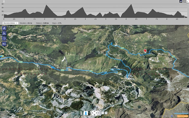
    "The 97th Tour de France will be made up of 1 prologue and 20 stages and will cover a total distance of 3,642 kilometers," says Bing’s Chris Pendleton. "I was looking at Le Tour de France site and they have this PDF route map – a bit antiquated. I’m going to go out on a limb and say you might want to check out the Bing 2010 Tour de France map app  for a better experience."

    Bing Tour de France Maps App

    Key features of the app include:

    – Each stage of the event being displayed on the map with pushpins to indicate the start and finish

    – Interactive profiles displayed along the top of the map, which lets you see elevation and slope changes for the selected stage

    – Stage description and weather prediction

    – Daily results.

    Pendleton says the best experience is in Bird’s Eye View (enhanced). More info about the app can be found here.

  • Bing Launches Facebook Maps App

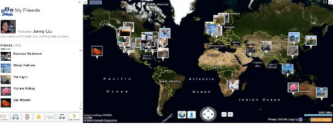
    Bing has launched a new Facebook Maps apps, which a Bing representative tells WebProNews uses Facebook APIs to pull in your friend’s information from Facebook. It lets you see your Facebook friends right in Bing Maps.

    With the My Friends map app, users can view profile pictures, status updates and write on someone’s wall, right from within the application. To use this, just start the app, log with you Facebook ID, and select "allow" to allow Bing Maps to connect to your profile (and to get your friend list).

    After you’re logged in, any friends who have a "current city" listed in their Facebook profile, will have their profile picture pinned to the map.

    Bing Maps Facebook app

    If you click on your friends’ pictures on the map, it will show their status.

    "We also have the de-clustering algorithm in place so if you have a number of friends in one place it will spin their photos into a circle and tether them back to the location with a line," explains Bing’s Chris Pendleton. "This is a great new way to watch your Facebook friends move around the world."

    Some Facebook users have been waiting for the company to launch location features. This was widely expected to be launched at F8, Facebook’s developer conference in April, but that didn’t happen (instead, they launched the game-changing Open Graph).

    This isn’t that location feature, and it doesn’t exactly make up for it. It possibly could in some ways if Facebook users updated their "current city" every time they made a status update, but this is only part of the "information" section in the user profile, which most people probably don’t update unless they move (although I’m sure some hardcore users update it more frequently). Either way, it’s not exactly reliable for seeing exactly where Facebook users are at any given moment.

    Still, the app is interesting enough to take a look at, as it does put into perspective where your friends reside.

  • Bing Maps Gets New Features, SDK for Apps

    Bing Maps Gets New Features, SDK for Apps

    Microsoft announced some new additions to Bing maps today. These additions, the company says, will benefit both developers and end-users.

    The first addition is that of a software development kit for building Map apps for Bing Maps. "Bing Map Apps are web services that are being integrated as an application layer within Bing Maps," says Bing Maps Tech Evangelist Chris Pendleton. "With the release of the SDK, developers can now create their own map apps built on top of Bing Maps and hosted on bing.com/maps/explore."

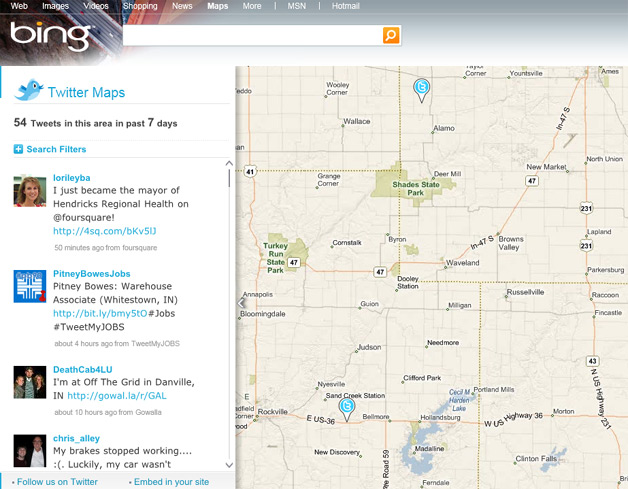
    That means we’re likely to see a lot of cool new ways to use Bing Maps. Microsoft has already been offering some interesting Bing Maps apps on its own. For example, Twitter Maps shows tweets from specific areas:

    Twitter Maps on Bing

    Microsoft has also released the following new features for Bing Maps:

    1. Bing Map App Ratings
    2. Photosynth Panoramas
    3. Map Overlays
    4. Action Bar
    5. Reverse Address Lookup
    6. Right-Click Menu
    7. Full Screen Maps
    8. Breadcrumb
    9. Brandfinder

    More details for each of these features can be found here.

    Finally, the Bing Maps Platform is expanding its interfaces to include a REST API. This provides geocoding, maps, and routing capabilities. In addition, they’ve introduced a Spatial Data API for reverse geocoding locations in batches, giving developers the ability to do even more with apps based on Bing Maps.

  • Google and Bing Launch Health Map Applications

    Today both Google and Bing released some health-related map applications. These releases coincide with the Institute of Medicine and the U.S. Department of Health and Human Services (HHS) hosting their Community Health Data Forum event.

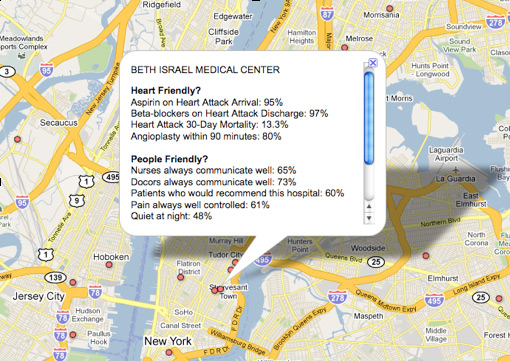
    Google’s contribution includes a Google Fusion Tables project and customized map showing information from HHS. For example, you can see a map of "heart friendly" and "people friendly" hospitals.

    Google Health Map

    "It’s important to note that the science behind measuring the quality of hospitals and health care in general is still evolving, so we can’t make definitive conclusions from this data," says Google’s Chief Health Strategist, Roni Zeiger, MD.  "However, this kind of transparency will lead to discussion, questions, and analysis which we hope will improve choices and outcomes."

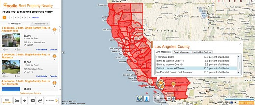
    Microsoft launched a Bing Maps app called Bing Health maps. This also uses data from HHS. It provides stats for the U.S. states by county.

    Bing Health Map App

    "Bing Health Maps is very straightforward to use – (1) Select a state and, (2) Select a Community Health Indicator," explains Bing’s Chris Pendleton. "The map will re-center on the respective state and color-code the counties within that state based on unit-based reporting. You can select health indicators such as Birth Indicators (low birth weight, premature births, births to women under 18, etc.); Death Measures (homicide, lung cancer, stroke, etc.) or Health Risk Factors (obesity, smokers, high blood pressure, etc.). If the opacity doesn’t suit your fancy there’s a slider to increase or decrease it."

    "Once the map is loaded with the respective counties shaded you can click on any county to get all of the factors listed under the Community Health Indicator list all in one popup for that county," continues Pendleton. "This app is jam-packed with information! Let’s say you’re looking to move California because you think everyone there is a health nut. Turn on the Bing Health Maps to see which counties are most healthy. Then, when you’re deciding to be a SoCal or NorCal person (the war wages on) you can fire up the Oodle Map App to check out rentals in the respective area. Or, check out the Twitter Map App and filter based on keywords like “running,” “hiking,” or “surfing” and you’ll finally find out that SoCal is just better since people aren’t Tweeting – they’re actually out running, hiking and surfing."

    More about the HHS Community Health Data Initiative can be found here.

  • Bing Maps Adds Three Useful Apps

    Bing Maps, which was already impressive in quite a few ways, has gotten better again with the addition of three new apps.  A distance calculator, gas prices tool, and parking finder promise to help people plan trips and go about their daily lives more efficiently.

    The distance calculator might be the least interesting app; pretty much every mapping service is able to tell the number of miles (or kilometers) between Point A and Point B, after all.  Still, this app can handle journeys with multiple legs, and take into account whether a person’s flying or driving.

    A handier app is then the gas prices tool.  It shows how much different stations are charging, and since it’s bundled right in with all of Bing Maps’s other offerings, could be a very convenient way of saving money.

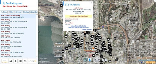
    Finally, although not a lot of whole cities are covered (just 16), the parking finder app may be able to save people from parking tickets, door dings, and vandalism when they’re visiting a number of airports (67).  A post on the Bing Maps Blog explained, "Once you select a parking lot by clicking on the respective pin on the map, you’ll get contextual information such as address, hours and a phone number.  You also get information about the type of lot such as outdoor and self-parking plus the payment types they accept."

    Furthermore, "There are links to view photos of the respective lot (on BestParking.com) or view the facility on BestParking.com," and "[c]licking the ‘Calculate Rate’ link for a parking lot will bring up a calculator where you enter your start and end date and times to estimate how much it will cost to park at all the lots listed on the map given the respective time!"

    These apps are all free, and don’t require any downloads so long as your computer’s already outfitted with Silverlight.  Just visit Bing Maps, agree to "Explore the new Bing Maps," and then click the "Map Apps" button.

  • Bing Launches Maps Apps for World Tour, Oodle, Foursquare

    Microsoft launched a few new apps for Bing Maps today: the World Tour App, the Oodle App and the Foursquare App.

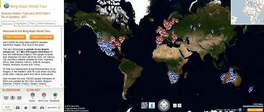
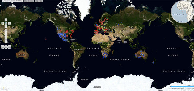
    "Just about every month, Bing Maps gets a makeover in the form of new map imagery for locations worldwide," a representative for Bing tells WebProNews. "The World Tour map app brings these updates to life using the Bing Map Apps framework, Silverlight and Azure."

    Bing World Tour app launched today

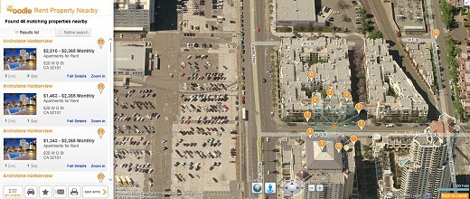
    "Oodle.com, one of the fastest growing classifieds services is creating an app that will map rental housing on Bing Maps which will be available today," he says. "The Oodle Rentals app will pull-in Oodle data, allowing users to look at various rental housing available from Oodle.com."

    Bing Oodle app launched today

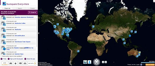
    "Last week at SES New York, we announced our partnership with foursquare and plans to roll out the foursquare Everywhere app on Bing Maps in the coming weeks," he notes. "Today, the app will be live and ready for use."

    Bing Foursquare app launched today

    That’s not all Microsoft announced for Bing at SES. They also announced an update to the Bing user interface, which adapts the page and search results based on the intent of the query.

    "We’ll be testing a new user interface that includes new design concepts that move the Quick Tabs functionality to the top of the screen, so customers see a more visual and organized page," the company said.

    They also announced a new search experience for autos. For more info on these updates, watch our coverage of Microsoft’s SES keynote and our exclusive interview with Bing Director Stefan Weitz.

  • Bing Maps Gets Biggest Imagery Update to Date

    Bing Maps Gets Biggest Imagery Update to Date

    Microsoft is rolling out the largest imagery update to Bing Maps to date, adding 6.7 million square kilometers of new imagery, a representative for Bing tells WebProNews.

    The update includes new aerial imagery for the Russian Federation, Australia, Mexico and most places in the US where there is existing black and white imagery. "There is also a notable addition of Bird’s Eye Imagery for Sweden," the rep says.

    Bing Maps gets largest imagery update ever

    Here’s a list as mentioned on the Bing Maps Blog:

    Aerial

    Australia    524,645 sq. km.
    Botswana    61,433 sq. km.
    Estonia    618 sq. km.
    Hungary    3,369 sq. km.
    Mexico    236,624 sq. km.
    Morocco    13,303 sq. km.
    Namibia    72,162 sq. km.
    New Zealand    14,987 sq. km.
    Poland    6,254 sq. km.
    Romania    3,695 sq. km.
    Russian Federation    553,244 sq. km.
    South Africa    123,138 sq. km.
    Turkey    16,148 sq. km.
    United Kingdom    15,221 sq. km.
    United States    4,961,758 sq. km.

    Oblique (Bird’s Eye)

    Austria    238 sq. km.
    Belgium    898 sq. km.
    Denmark    718 sq. km.
    Finland    1,634 sq. km.
    France    2,001 sq. km.
    Greece    931 sq. km.
    Ireland    1,340 sq. km.
    Netherlands    1,709 sq. km.
    Norway    2,425 sq. km.
    Portugal    2,184 sq. km.
    Romania    1,534 sq. km.
    Spain    5,143 sq. km.
    Sweden    6,747 sq. km.
    Switzerland    424 sq. km.
    United Kingdom    13,094 sq. km.
    United States    56,007 sq. km.

    Last month Bing had pushed out its biggest imagery update to that point, but as Chris Pendleton says on the blog, this one blows that record out of the water.

    Visuals can be seen via the

    Bing Maps World Tour.