WebProNews

Tag: Bing Maps Apps

  • Lots Happening with Bing Maps Today

    "Bing Maps just got more useful for developers, bus and train commuters and education advocates everywhere," a representative for Bing tells WebProNews. She is referring to a series of announcements Microsoft made today regarding Bing Maps. 

    The company released two new Bing mapping apps, made additions to the Bing Transit Map, and released the final Windows Phone 7 SDK which features Bing and Microsoft Advertising.

    Education

    Bing’s  two new mapping apps are part of the Our School Needs campaign, which is focused on supporting schools across the U.S. through funding and volunteer efforts.

    The first app is for DonorsChoose.org. It helps people find and support classroom projects in their community. "The app identifies and highlights school projects that are looking for funding," the rep explains.  "People can explore and donate by location, subject area, funding required and other criteria. Schools, school districts and donors can also embed a DonorsChoose Bing Map in their own website making it easy to spread the word."

    The second app is simply  Bing Education. It’s designed to help people find opportunities to help students in their neighborhoods. "In addition to features found in the DonorsChoose.org app this app displays local school information and donation, mentor, and volunteer opportunities in the area," she says. "The app features opportunities from Mentor Pro, Great Schools, and DonorsChoose.org."

    Transit

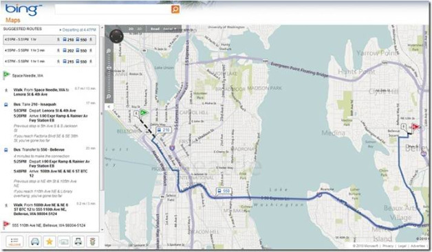
    As far as additions to Bing Transit Map, bus and rail transit directions are now alongside driving and walking directions. The transit directions will first be available in major U.S. metropolitan areas such as Boston, Chicago and Los Angeles, and will roll out to additional cities in the future. "The information in the Bing Transit map is provided by various transportation agencies in major metropolitan regions," says the rep. "Please note, Bing Transit only works on AJAX supported sites."

    Bing Maps Transit

    More details and a complete list of available cities can be found here.

    Windows Phone 7 SDK

    Bing Maps, which is of course the default mapping service on Windows Phone 7, is now fully integrated into the Windows Phone 7 Developer Toolkit with the Bing Maps Control SDK. Bing says this makes it simpler for developers to build Bing mobile mapping apps. "Like all other Bing Maps APIs, the Windows Phone 7 control is free for use in consumer-facing mobile applications," the rep says. More info on Windows Phone Developer tools are here. More on the Advertising SDK specifically here.
  • Bing Maps Gets OpenStreetMap App

    Bing Maps Gets OpenStreetMap App

    Microsoft has launched a new Bing Maps app for OpenStreetMap. The app adds a layer on Bing Maps as a new style option.

    "OpenStreetMap follows a similar concept as Wikipedia, but for maps and other geographic facts (despite its name, it’s by no means only limited to streets and roads)," explains Bing’s Chris Pendleton. "People, like you and me, gather location data across the globe from a variety of sources such as recordings from GPS devices, from free satellite imagery or simply from knowing an area very well, for example because they live there. This information then gets uploaded to OpenStreetMap’s central database from where it can be further modified, corrected and enriched by anyone who notices missing facts or errors about the area."

    Bing Maps Adds OpenStreetMap

    "Users can still perform searches atop of the OSM map layer," adds Pendleton. "Once the OSM Maps are rendered, users will find the OSM map option listed in the map types so if you switch to Bird’s Eye or some other native Bing map types, you can easily return to the OSM map style. Of note, we are using the Mapnik map style from OSM (one of the many map styles available to open source users) to create our OSM map type. People love the details you see?"

    It should be interesting to see how the OpenStreetMap grows from community participation, and how it looks compared to other map offerings.

    Bing is doing some interesting things with maps through its Maps Apps. They’ve recently launched apps for Facebook, Foursquare, health, and the Tour De France, not to mention Mars imagery.

  • “King of Bing Maps” Soon To Be Determined

    Update: Microsoft announced that the "King of Bing Maps" contest is now closed. They will determine the winner soon.

    Original Article: Bing has announced that it’s searching for "someone to worship." By this, they mean lead the way in Bing Map App development. So naturally, they’ve launched a contest.

    The contest is called the "King of Bing Maps Challenge," and the winner gets a $1,000 Bing Travel gift card. 2nd prize gets a $500 card and 3rd gets a $250 card.

    Winners, selected by a panel of industry experts, will be announced August 20. 

    Bing requires applicants submit their map app by July 25th. The official rules can be found here. Bing’s Chris Pendelton cites the following steps:

    1. King of Bing Maps Contest launchedRead about the King of Bing Maps contest at www.KingOfBingMaps.com.
    2. Download the Bing Map App SDK (Live ID required). If you don’t know anything about it or if you haven’t read my blog post, read my post about the launch of the Bing Map App SDK – “Announcing the Bing Map App SDK…and 3 New Bing Map Apps”.
    3. Start with the template provided in the SDK. The template is our Hello World for Bing Map Apps. Visual Studio 2010 and Silverlight 4 SDK required.
    4. Build a sick ass application. I mean disgusting.
    5. Submit your application to the Bing Maps Portal.
    6. Wait for the judges to determine your fate.

    The contest is no doubt designed to generate more interest in the creation of Bing Maps Apps, one feature that sets it apart from other search engine maps.

  • Bing Takes Users to Mars

    Microsoft has added Mars imagery to Bing Maps and to its WorldWide Telescope project. The imagery comes straight from NASA itself.

    "Microsoft Research and NASA are providing an entirely new experience to users of the WorldWide Telescope, which will allow visitors to interact with and explore our solar system like never before," says Bing’s Chris Pendleton. "Viewers can now take exclusive interactive tours of the Red Planet, hear directly from NASA scientists, and view and explore the most complete, highest-resolution coverage of Mars available."

    Bing Mars Imagery

    "The beauty of this is that the Bing WorldWide Telescope Map App has been updated with the new imagery, as well," adds Pendleton. "This means users of Bing Maps can immediately enjoy the new imagery of the Red Planet from within their browser via our Silverlight site."

    The Worldwide Telescope Mars experience can be downloaded here. On the Bing Maps Silverlight site, users can simply click the "Map Apps" button, select "WorldWide Telescope", and select "Mars" from the Collections list.

  • Bing Launches Tour De France Bing Maps App

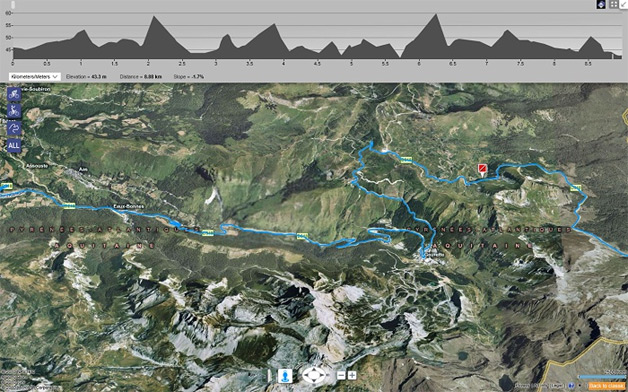
    Microsoft’s Bing has been doing some really interesting things with Bing Maps, and more specifically Bing Maps Apps. This week, the company launched a new map app for the Tour De France, which starts today and runs through July 25th.

    "The 97th Tour de France will be made up of 1 prologue and 20 stages and will cover a total distance of 3,642 kilometers," says Bing’s Chris Pendleton. "I was looking at Le Tour de France site and they have this PDF route map – a bit antiquated. I’m going to go out on a limb and say you might want to check out the Bing 2010 Tour de France map app  for a better experience."

    Bing Tour de France Maps App

    Key features of the app include:

    – Each stage of the event being displayed on the map with pushpins to indicate the start and finish

    – Interactive profiles displayed along the top of the map, which lets you see elevation and slope changes for the selected stage

    – Stage description and weather prediction

    – Daily results.

    Pendleton says the best experience is in Bird’s Eye View (enhanced). More info about the app can be found here.

  • Bing Launches Facebook Maps App

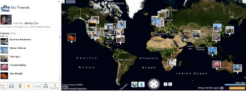
    Bing has launched a new Facebook Maps apps, which a Bing representative tells WebProNews uses Facebook APIs to pull in your friend’s information from Facebook. It lets you see your Facebook friends right in Bing Maps.

    With the My Friends map app, users can view profile pictures, status updates and write on someone’s wall, right from within the application. To use this, just start the app, log with you Facebook ID, and select "allow" to allow Bing Maps to connect to your profile (and to get your friend list).

    After you’re logged in, any friends who have a "current city" listed in their Facebook profile, will have their profile picture pinned to the map.

    Bing Maps Facebook app

    If you click on your friends’ pictures on the map, it will show their status.

    "We also have the de-clustering algorithm in place so if you have a number of friends in one place it will spin their photos into a circle and tether them back to the location with a line," explains Bing’s Chris Pendleton. "This is a great new way to watch your Facebook friends move around the world."

    Some Facebook users have been waiting for the company to launch location features. This was widely expected to be launched at F8, Facebook’s developer conference in April, but that didn’t happen (instead, they launched the game-changing Open Graph).

    This isn’t that location feature, and it doesn’t exactly make up for it. It possibly could in some ways if Facebook users updated their "current city" every time they made a status update, but this is only part of the "information" section in the user profile, which most people probably don’t update unless they move (although I’m sure some hardcore users update it more frequently). Either way, it’s not exactly reliable for seeing exactly where Facebook users are at any given moment.

    Still, the app is interesting enough to take a look at, as it does put into perspective where your friends reside.

  • Bing Maps Gets New Features, SDK for Apps

    Bing Maps Gets New Features, SDK for Apps

    Microsoft announced some new additions to Bing maps today. These additions, the company says, will benefit both developers and end-users.

    The first addition is that of a software development kit for building Map apps for Bing Maps. "Bing Map Apps are web services that are being integrated as an application layer within Bing Maps," says Bing Maps Tech Evangelist Chris Pendleton. "With the release of the SDK, developers can now create their own map apps built on top of Bing Maps and hosted on bing.com/maps/explore."

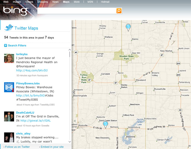
    That means we’re likely to see a lot of cool new ways to use Bing Maps. Microsoft has already been offering some interesting Bing Maps apps on its own. For example, Twitter Maps shows tweets from specific areas:

    Twitter Maps on Bing

    Microsoft has also released the following new features for Bing Maps:

    1. Bing Map App Ratings
    2. Photosynth Panoramas
    3. Map Overlays
    4. Action Bar
    5. Reverse Address Lookup
    6. Right-Click Menu
    7. Full Screen Maps
    8. Breadcrumb
    9. Brandfinder

    More details for each of these features can be found here.

    Finally, the Bing Maps Platform is expanding its interfaces to include a REST API. This provides geocoding, maps, and routing capabilities. In addition, they’ve introduced a Spatial Data API for reverse geocoding locations in batches, giving developers the ability to do even more with apps based on Bing Maps.

  • Google and Bing Launch Health Map Applications

    Today both Google and Bing released some health-related map applications. These releases coincide with the Institute of Medicine and the U.S. Department of Health and Human Services (HHS) hosting their Community Health Data Forum event.

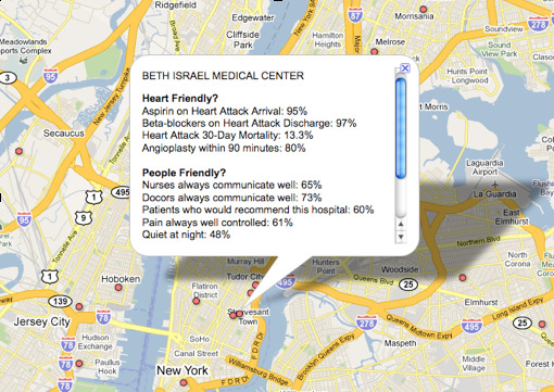
    Google’s contribution includes a Google Fusion Tables project and customized map showing information from HHS. For example, you can see a map of "heart friendly" and "people friendly" hospitals.

    Google Health Map

    "It’s important to note that the science behind measuring the quality of hospitals and health care in general is still evolving, so we can’t make definitive conclusions from this data," says Google’s Chief Health Strategist, Roni Zeiger, MD.  "However, this kind of transparency will lead to discussion, questions, and analysis which we hope will improve choices and outcomes."

    Microsoft launched a Bing Maps app called Bing Health maps. This also uses data from HHS. It provides stats for the U.S. states by county.

    Bing Health Map App

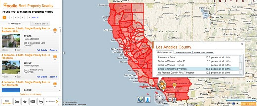
    "Bing Health Maps is very straightforward to use – (1) Select a state and, (2) Select a Community Health Indicator," explains Bing’s Chris Pendleton. "The map will re-center on the respective state and color-code the counties within that state based on unit-based reporting. You can select health indicators such as Birth Indicators (low birth weight, premature births, births to women under 18, etc.); Death Measures (homicide, lung cancer, stroke, etc.) or Health Risk Factors (obesity, smokers, high blood pressure, etc.). If the opacity doesn’t suit your fancy there’s a slider to increase or decrease it."

    "Once the map is loaded with the respective counties shaded you can click on any county to get all of the factors listed under the Community Health Indicator list all in one popup for that county," continues Pendleton. "This app is jam-packed with information! Let’s say you’re looking to move California because you think everyone there is a health nut. Turn on the Bing Health Maps to see which counties are most healthy. Then, when you’re deciding to be a SoCal or NorCal person (the war wages on) you can fire up the Oodle Map App to check out rentals in the respective area. Or, check out the Twitter Map App and filter based on keywords like “running,” “hiking,” or “surfing” and you’ll finally find out that SoCal is just better since people aren’t Tweeting – they’re actually out running, hiking and surfing."

    More about the HHS Community Health Data Initiative can be found here.